Marsannay-la-Côte 7400 years ago.
Publié 18/10/2018 16:28:08 Modifier 11/07/2019 10:04:11 par 489945901
Increased walking tour with new technologies, compilation of more than 100 years of work of many archaeologists in the region, 7400 years ago, in the footsteps of the last hunters and peasants.
Period: -5400 to -300 years. #History #Tumulus #Circuit # Marsannay-la-Côte
Hiking circuit increased with new technologies.
Total: 15,3 Km
Time: about 3 hours 30 minutes.
Level: Easy.
Type: Loop with return flow.
Picnic: Many clearings.
Easily modifiable, meaning of departure not important, many shortcuts marked.
Below you will find the following items:
The story of the birth of the circuit,
A link Google Maps with the course mapped to +/- 4 meters precision of the 6 places to see,
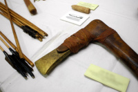
The list of 6 places with a link to the work of archaeologists, dating, discovered objects, buried bodies.
The story of the birth of the circuit.
It is the compilation of over 100 years of work by many archaeologists.
All disappeared these watchmen have left traces in the digital world decrypting those left by the forgotten history, their ruins lost in nature remind walkers that the land they are treading, them, these first farmers, defended it, worked on it and respected it for hundreds of generations, until very old times were burying it for eternity.
Thanks to the article published in 2007 by Jean-Pierre Devaux ( deceased on May 28, 2015 ), amateur archaeologist, which presents a synthesis of the work of several archaeologists over 110 years, this dive into the very ancient history of the region is possible . A link to the original article is provided under the title " The Protohistoric Environment of Mount Africa ".
The detailed information for each Tumulus is repeated without any modification of the original article.
Finding the exact locations of tumuli required a year of research.
Respect these places.
Google Maps with the course mapped to +/- 4 meters precision of the 6 places to see.
How to use Google Maps offline
To reach the places you can guide you with the geolocation.
Google Maps is today one of the best GPS applications available. Its cards are only accessible online, and it is necessary to do a little manipulation before you can use it offline.
Open the Google Maps menu at the top right icon ≡
Select Offline Zones:
To download a particular area, position yourself on it and in the middle.
Google then offers to save the area, or to add another area with the "+" button in the lower right. Click on it and you will have a frame allowing you to choose the limits of the zone to be recorded.
Zones are optimized (32MB).
In order to easily manage your offline maps, Google will ask you for a name defining the zone in question when saving.
Automatically, the name will be defined by that of the zone.
A card thus registered can be used for offline navigation for a period of 29 days.
By going to the Offline Zones section or in Your addresses, you can easily manage your downloaded maps, delete them or update them.
Link to the Google Maps circuit:
https://www.google.fr/maps/d/viewer?mid=18HoBK0eslcI6RzwU3CVlyl5kCb8
The list of 6 places with a link to the work of archaeologists.
1- Tumulus of the Rente-Neuve: https://www.freewalldisplay.com/posts/post/34
2- Young Bramble Wood Tumulus: https://www.freewalldisplay.com/posts/post/33
3- Tertre du Bois Boujon: https://www.freewalldisplay.com/posts/post/31
4- Tumulus of the Bois de Taviard: https://www.freewalldisplay.com/posts/post/32
5- Tumulus of the Mountain: https://www.freewalldisplay.com/posts/post/29
6- Tumulus of the Combe Pévenelle: https://www.freewalldisplay.com/posts/post/30
Back to the starting point.
Do not hesitate to comment, criticize and share this ride.
You can also participate, this site is collaborative.